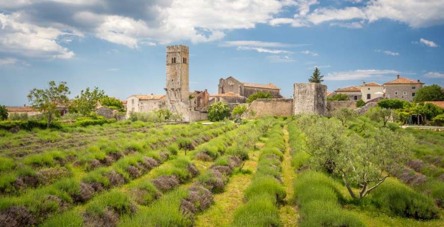
Explore Pazin

Pazin is the administrative center of Istria County and already in the 19th century, mostly because of its central position on the Peninsula, but importance as well, came to be called the “heart of Istria”. The fascinating picture of the medieval Castle of Pazin (Kaštel), situated above the 130 m cliff where the Pazinčica River flows into the Pazin Pit, inspired the renowned French writer Jules Verne as the setting for part of his novel “Mathias Sandorf”, published in 1885.

Events and festivals

Create memories - try something new in Istria!

Experience
Experience
Pazin / 30.11. - 30.04.24

Network of Motovun gatherings

More
Experience
Pazin / 07.12. - 30.11.24

What do we do when we do nothing

More
Experience
Gračišće / 01.04.24

Gračišće Wine Review

More
Experience
Pazin / 05.04. - 07.04.24

AgroTerra Istra

More

Town and surroundings

  • Beram

    Beram is one of the oldest continuously populated settlements in Istria. Explorations of the prehistoric necropolis on the south slopes of Beram have shown with certainty that during the iron age a settlement already existed here.

    A conical hill above a fertile valley was an ideal place for a hill-fort type settlement, surrounded by a simple rough wall following the terrain configuration. Over the ruins of these walls Roman forts and medieval castles were later built. A radial street pattern founded in some ancient times has been preserved in Beram untill today.

    The Beram hill-fort of the first phase (untill the VIII.cent. BC) enclosed about thre same area the town includes today. Entrance is at a place that is still being used as an auxilliary entrance, and local people call it „the small gates“. Outside the hill-fort wall, at the southern hillside, was the necropolis – a place to burn and burrow the dead. As the hill-fort settlement was later spreading down the southern hillside the necropolis kept moving to be beyond the outside wall.

    Beram - a medieval fort at the second line of defense of the Pazin principality
    Beram was first mentioned in a written document in the year 911., in a deed of gift by king Berengar to the bishop of Trieste. In the middle ages it was fortified with defensive walls above which was rising, at the place where the parochial church stands today, a square watchtower, from which there was a secret undergroun passage leading to Jamorina cave next to the creek at the hillfoot. Although in parochial sense it belonged to Poreč diecese, Beram was part of the lands belonging to the counts of Gorizia, and later to Pazin principality, and it had a status of castle, and beginning with 1578. of a small town. During numerous armed conflicts between the Pazin principality, enclosing the central part of Istria with center in Pazin, and Venice, which reigned over neighbouring Motovun and the entire Istrian coast, the Beram castle played an important role, but due to that it also often suffered attacks and destruction.

  • Gračišće

    Only fifteen years ago it seemed that this old little town standing over the hilly landscape of central Istria had been ignored by modern changes. Life was thriving here already in prehistory and it is said that the name Gallignana was given to the town by the ancient Gauls more than two thousand years ago.A more active life was brought in by the Slavs, whose spiritual heritage can still be discerned in the name of the hill – Perunčevac, named after Perun, the highest Slavic god, but also in the thousand-year old worshipping of Svantovid, the origin, some people believe, of the Christian St. Vitus, Patron of the Parish of Gračišće.

    Gračišće is the centre of the Gračišće Municipality, which extends over 60 square kilometres and has a population of about 1500 people. The well preserved landscape has encouraged a few households to engage in agritourism. The traditional commitment to wine production, on the other hand, has given rise to an already popular annual Exhibition of the Wine of Central Istria. The beauty and singularity of cultural and historical monuments located in the preserved landscape are the greatest value of Gračišće. The town is visited by more and more visitors every day, not only for the Exhibition of the Wine of Central Istria, the St. Vitus Feast or the Festival of the Harmonica Zasopimo na organić. Many enthusiasts often come to this town to feed on the tranquillity inundating its streets lined with old architecture and converging at the tall bell tower and the parish church, both from the 18th century. Everyone will receive a gift here: from the lawn surrounding the church, visitors obtain probably one of the most beautiful views extending over the undulating landscape of Istria, merging into the peaks of the lofty Učka Mountain.

  • Boljun

    Boljun is an ancient town in the northeast of Istria, in the Lupoglav Municipality. It was built around the well-preserved medieval castle. The town has a wide view of the Boljunčica Valley and the Učka mountain range. From the 15th to the end of the 17th century this not a town, not a village place reached the peak of its development.There was a judge and town mayors, numerous altars were taken care of by fraternities, glagolithic script was used and taught.

    Since then, Boljun has lost its importance and life has almost stopped. However, the town has not collapsed but surprises every tourist with pleasant prospects.

    Guests thirsty for rest can find everything they need in Boljun: comfortable accommodation, intact nature, peace and, of course, unique local specialities in the local konoba (tavern).

  • Cerovlje

    Cerovlje is the central place of a large municipality spreading over the undulating landscape northeast of Pazin and comprising numerous hamlets and villages: Draguć, Grimalda, Gologorica, Paz, Borut, Pazinski Novaki... Such natural features brought to it plentiful particularities throughout history and continuing until the present time.

    Inaccessibility and isolation were the reasons for the very poor or non-existent influence of Rome to this remote piece of its province. Pathless ravines in the east, fortified by carefully arranged forts (Gradina, Paz, Šabec, later Belaj, Posrt) in the Middle Ages created an unassailable frontier used by the Istrian Margrave to expand his dominion which was further defended by the forts of Boljun, Lupoglav, Roč, Črni grad and Beli grad in the north and Letaj, Barban, Rakalj and Sutivanac in the south. The slow arrival of modern changes to the secluded villages, which were only recently upgraded with good roads, led to the depopulation and complete abandonment of some villages. On the other hand, it also influenced the preservation of many ethnologic particularities and the way of living, which have already been made history in other parts of Istria.

    If you are searching for the true rural Istria – you are in the right place.

  • Draguć

    Behind seven hills, in the deepest inland of Istra, half way between Pazin and Buzet suddenly emerges - Draguć. Situated in the middle of nowhere, squeezed on the ridge of a hill, it simply allures you with its harmonious ancient perspective.

    Due to the fact that many movies have been filmed here and numerous film stars have walked its streets Draguć has been for long babbled the name of – Istrian Hollywood.

    Still, Draguć is not just a coulisse. The supreme vivid frescoes in the adorned churches along with their sacred treasure are the target of the curious tourists, while the cosy accommodation gives You the opportunity to have the main role in this silence-prevailing surrounding. Quiet - action!

    Draguć as we know it today was formed around the homonymous medieval castle, which is nowadays almost completely incorporated in the architectural structure of the later periods. Mentioned in 1102 as deed of conveyance by the Istrian Margrave Ulrich to the Aquileia Patriarchs, later as part of the future Pazin County it belonged to the Counts of Gorica and finally to the Habsburgs.

    The town was attacked while the settlement surrounding the Castle was burnt and destroyed by both Ottomans and Venetians, and when it eventually came under the reign of Venice, – Uskoks and Austrians did the same.

    What wars had begun the plague continued on more occasions and in 1855 cholera put the end to it having decimated the population. That the town survived is a pure miracle just as it is the fact that so much has been preserved up to the present times.

  • Rakotule

    Rakotule is the common name for a number of small villages and hamlets situated in the present-day north of the road which connects Karojba and Višnjan: Konobari, Kramari, Kuzmi, Martineli, Milići, Močitad, Nadalini, Pahovići, Pupičići, Radoslavi, Rapki and Špinovci. Špinovci is the only hamlet which does not belong to the Parish of St. Roch but to the Parish of St. Vitalis. The centre of Parish is the St. Vitalis' Church, whose harmonious stone tower can be seen from the road as soon as we turn on the road to Rakotule.

    Rakotule is mentioned for the first time in the 13th century. The Italian name Racotole di Montona reveals the close relationship with the nearby Motovun-Montona, which can be seen from many points as though in the palm of your hand. The links goes far back into the past, when the aristocratic families of Motovun had their estates at Rakotule: Dolzan, Pramperga (or Pamperga), Polesini and Barbo. The Motovun Chapter also had their estates at Rakotule and the majority of the income was obtained from the woods on the slopes above the Krvar brook. Timber was transported on the Mirna River to the sea and from there to Venice where it was used to build ships of the mighty Venetian fleet which dominated the Adriatic Sea.

  • Karojba

    The wooded hills surrounding Karojba, around the springs of Valigaštar and Vrućak, still abound in historical sites that have not been fully researched. Hadum - brig, Krč, Liretov brig, Glogovac, Šublenta... all these hills have been inhabited since prehistoric times but razed to the ground on several occasions making it difficult for the historians to put the fragments together into a unique story. The majority of them, however, agree that, at Roman times, the area around the spring of Valigaštar contained a Roman military camp near which Roman roads crossed – the modern-day name of Karojba probably derives from the Roman name Quadrivium  – a crossroads.

  • Kringa

    Kringa is situated five kilometres southern of Tinjan on the spot of the Iron Age edifice later a Roman fortress, the second largest settlement in the Tinjan municipality. Among the founds from the Earlier Stone Age there are remarkably, almost artistically elaborated idols. Written sources take account of Kringa from 1102 onwards under the name of Curitico or Coriticum. In the Middle Ages it is the constituent part of the Pazin principality.

    In the central part of the settlement there is the parish church of St. Peter and St. Paul's from 1787 along with the piazza adorned with two rustic stone cisterns and a hackberry (Celtis australis) tree.The notable Istrian priest and community worker Božo Milanović (1890-1980) was born in Kringa. He was also on of the Istrian representatives on the 1946 Paris peace conference, where the Istrian post-war destiny was defined. A memorial stone in his honour was placed on the building where he lived and worked. This fairly small village has other three older churches which can be explored by taking a short circular walk: St. Anna's church from 1558 on the cemetery, St. Catherine's church and St. Anthony the Abbot’s church, along with the rustic Calvary built in 1876. Nowadays Kringa has been more and more notable for Juro Grande, the oldest European vampire and for the unusual events from 1672 related to his character of which Johann Weikard Valvasor took account.

    Jure Grando and the nine brave men
    Jure Grando is the earliest European vampire to be recorded in written documents by given and family name. The testimony of his elimination in 1672 was recorded by Johann Weikhard Valvasor, famous Slovenian traveller and writer in his book The Glory of the Duchy of Carniola.
    According to Valvasor`s records, Jure Grando was an inhabitant of Kringa, who died and was buried in the usual way in 1656. But on the first night after the funeral he rose from the grave, wandered around Kringa banging on house doors where soon somebody would die. He would also visit his widow every night, forcing her to comply with her marital duties

    After sixteen years of such terror, the mayor of Kringa, Miho Radetić, gathered nine people from the village. They opened Grando`s grave, found in it the completely preserved body with rosy cheeks. After unsuccessfully trying to pierce the body with a hawthorn stake, they cut off his head and refilled the grave. Valvasor concluded his record by saying that Jure Grando molested the inhabitants of Kringa never again.

  • Lindar

    While we are approaching Pazin, taking the road that goes north-east through the valley of the Pazinčica rivulet, we will spot the bell tower of Lindar at the hilltop ahead of us, peeping out from the dense forest as if it was watching us. We should recall the scene again, once we visit this prehistoric site. Such a prominent position of the guard must have been one of the main reasons for the construction of Lindar, which was once a fort girdled by strong walls and towers. The fort used to protect the entrance to Pazin Castle, from which it is only 2.5 km away. This is the reason why antiquity scholars claim that a prehistoric settlement must have existed on this particular site. Yet, no solid physical evidence has been found up to the present day, apart from a pottery fragment and a piece of an iron object from the neighbouring hilltop, where today the cemetery of Lindar is.

    It was from the Lindar lookout where defenders observed numerous tumultuous events that unfolded in the valley beneath them. They witnessed the count of Krk, Ivan Frankopan together with his soldiers, devastate Cerovlje and Zarečje in 1463,after which he heads towards Pazin Castle but eventually, instead of attacking it, he moves towards the not so well-protected Kašćerga and Sovinjak. They also monitored moves and breakout attempts from the Turks, who in 1501 encamped in the close proximity to Lindar, along the today’s road to Velanov brijeg. With deep anxiety they watched the intervention of Captain Lazarić at dawn of 4th September 1813, when together with only 47 soldiers and helped by a lot of pheasants, whose role was to make noise, he attacked the French army beneath Lindar and forced it to flee to Pazin, which brought the whole Istria back under the Austrian rule. It is said that the women of Lindar contributed to the stratagem of the Captain too, by positioning their spindles in a way that these protrude from the walls, thus suggesting that the fort was well-defended.

    At Lindar, the Glagolotic script, which is the oldest Slavic script, had been used from time immemorial. Apart from the original Glagolitic inscriptions carved in stones in the churches of St. Martin, St. Sebastian, and St. Mohor and Fortunato, there were also graffiti on the frescoes in the church of St. Catherine. The registers of Lindar were written in Glagolitic script from their introduction in 1590 until 1667, while in the 15the century, a Glagolitic priest Petar Fraščić was active in Lindar. He bequeathed to us one, and so far the only known commented Glagolitic psalter, which he wrote in 1463 for "priest Matija of Kubed".

  • Lupoglav

    You can find Lupoglav at the crossing of the roads, the modern-day Lupoglav is the centre of a municipality spreading out from the slopes of the Učka and the Ćićarija down to Boljun Valley in the south. The place is teaming with new family detached houses built along the road. However, there is no familiar vertical of a bell tower so often found in other Istrian places marking their centres. How come? In order to understand the current situation, one must raise their eyes towards the steep slopes of the Ćićarija and look for an elevation where the Mahrenfels Castle, the residence of the Lupoglav allodial estate, stood until the mid 17th century. The Castle was situated about 1.5 km east of today's town.

  • Pićan

    Pićan, Petina, Petinum, Pedena, Penna, Biben, Pyben, Piben, Piebn, Piebnn, Pitchann....
    What's in a name? Sometimes it is not easy to follow the traces of Pićan in historical sources due to its numerous names. The origin of the name Petina is sometimes attributed to the assumption that the Diocese of Pićan was the fifth in the world where the word pet (five) contains a Celtic root.

    Pićan was definitely settled in early prehistoric times. The oldest parts of the fortified hilltop town of the tribe of Histri were located on the Calvary Hill, north of the modern town. After that the town was probably settled by the Celtic tribe of the Secusa. In Roman times, probably on the same strategically important location, there was a military stronghold and the settlement Petina.

    Some authors linked the town of Pićan to the name Pucinium, mentioned by Pliny and Ptolemy as the name of a fortification in central Istria, famous for its excellent wine even in the Roman Court. Livia, wife of the Emperor Augustus, believed that her longevity was attributed to the fact that she would drink only this wine. The only visible evidence of the Roman presence is the inscription on the stone incorporated in the doorpost of the house facing the bell tower. The inscription mentions a Lucius Caonalius of the family Pupinia that can be found in various other places in Istria (Kringa, Pula, Poreč, Koper, Trieste).

    At the time of the Byzantine rule Pićan was the administrative centre of central Istria. From the Late Antiquity to the end of the 18th century, Pićan was the seat of the Diocese of Pićan, one of the oldest, but also smallest in the Christian world in general.

  • Sveti Lovreč

    Sveti Lovreč nestles in the immediate hinterland of Vrsar-Orsera and Poreč. It is one the best preserved medieval fortified towns in Istria, The town was named after the small church St. Lawrence built in the 8th century on the town graveyard located outside the town. The Romanesque bell tower next to the church was added in the 11th century.

    The circular shape of the settlement originates from the prehistoric period when a hillfort was located on the hill top. During the Byzantine era Lovreč had already been fortified with walls and towers, which were later thoroughly restored on various occasions. Most of the remaining fortifications date back to the Venetian era when Sveti Lovreč was the seat of the military administration of the Venetian Istria – the so called pazenatik.

  • Sveti Petar u Šumi

    The village of Sveti Petar u Šumi, presently holding the status of Municipality, was named after the Benedictine monastery mentioned in Latin documents under the name Monasterium Sancti Petri in Sylvis – the Monastery of Saint Peter in the Woods. The Monastery was first recorded in documents in 1174 but the record is accompanied by the annotation saying that the Monastery had stood there for 50 years. It is quite certain that the Monastery existed even before 1134. The legend says that the Hungarian King Solomon spent some time at Sveti Petar u Šumi after losing the throne in dynastic fights. Later he moved on to the Monastery of Saint Michael in Pula-Pola where he died in 1089.

    Only one book from the Monastery library remained preserved. It is a Latin manuscript written in Caroline script towards the end of the 11th or beginning of the 12th century. A fragment inscribed with Cyrillic and Glagolitic letters dates back into the same period – proving that the Benedictine monks at Sveti Petar used all three local alphabets. The Benedictines were the first Western European monks, they contributed greatly to the restoration of economy and cultural activities, providing for both body and soul in accordance with the motto they strictly adhered to: Pray and work! Ora et labora!

    Unlike other Istrian villages and towns, which were formed on hills having the church on top and houses set along the church and the edges of the hill, at Sveti Petar there were no houses around the church or the monastery in order to ensure serenity and composure of the monks. The inhabitants of Sveti Petar lived in nearby villages working their fields and vineyards. Overlooking the Draga Valley there stood until the 15th century a fortified castle, mentioned in the monuments as Ad Vicinatum (maybe today's Vižinada). Nothing remains of the castle except for the place name Sveti Toma (Saint Thomas) after a church that also no longer exists.

  • Tinjan

    Tinjan has always been a border area town. In the time of the Romans Attinianum protected the borders of Poreč's ager (from Latin: state owned land for public use) from the poorly Romanized peninsular inland and it also monitored the route towards Tarsatica. During MiddleAges it became one of the pillars of Majnard Črnogradski's properties in Pazin-Pisino and along with the Pazin-Pisino castle got by means of a wedding liaison under the rule of the Gorica earls. It was for them that Tinjan fortress safeguarded the often attacked west borderline towards the Aquileia patriarch's properties. In the same way from 1374 till the Napoleonic rule it protected its new owners , the imperial family Habsburg, from the fervent borderline of the Pazin-Pisino county towards the Venetian properties. Despite being itself a borderline Tinjan has never been a solitary fortress but on the other hand since 1587 it has proclaimed itself –a town.

    Today Tinjan is a place that proudly preserves its history and tradition whether it relates to the symbols of the area – stone dry walls and pools, Istrian traditional tools (kosiri and rankuni), folklore and architectural heritage, folk tales or legends, or relating to superior gastronomic specialities such as Istrian smoked ham (pršut).The tradition of the production of superb smoked ham is nowadays in Tinjan area preserved by numerous registered smoked ham manufactories and in 2006 Tinjan proclaimed itself the Municipality of Istrian smoked ham.

    Another significant tradition of this region is the blacksmith trade with the wide known kosir (a miniature version of sickle always carried by the locals), so that during the festivities of St. Simon's Day in Tinjan there is the traditionally held festival of kosir and other blacksmith's craftworks where all the blacksmiths from Istra gather.

Where would you like to stay?

Explore
Središnja Istra
6 °C
  • Tue
    7 ºC
  • Wed
    5 ºC
  • Thu
    6 ºC
source: DHMZ
How to get there?
  • Car
  • Bicycle
Time
-
-
9:30 h
0:30 h
Distance
-
-
276,4 km
277,4 km
source: Google Maps
Contact
Show